| This article is under construction and/or revamp and will be completed at a later date. If this article has not been edited in several days, please remove this template. This article was last edited by Javants (talk| contribs). (Update) |
By all means, please help fix spelling, grammar, and organization problems. Thank you.
| City of Rossterre Cité de Roixterre |
|
 | |
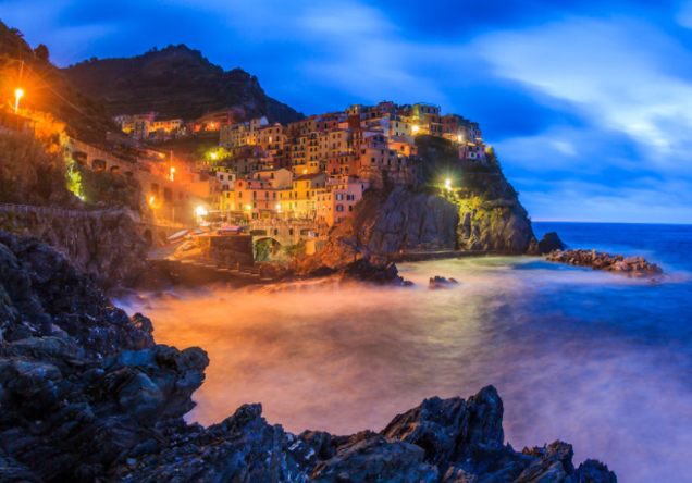
| Clockwise from top: National Museum of Helvore, Skyline of Rossterre in Essterre, Ponte Rue Noir on the St. Crimse River, Skyline of Rossterre from the Bay of St. Crimse at night, Royal Palace of Rossterre | |
 |
 |
| Flag | Coat of Arms |
| Motto: "L'Aele des Roisen" English: "The Birthplace of Kings" |
|
 | |
| Location within Helvore | |
| Country | |
| State | Tosque |
| Administrative Divisions | 26 Arrondisementes |
| Government | |
| - Duke | Pierre-Alexandre Biscelle |
|---|---|
| Area | |
| - Total | 1,148.71 km² |
| Population (June 2016) | |
| - City | 4,362,893 |
| - Density | 2.63 /km² |
| Time Zone | WET (UTC-1) |
The City of Rossterre (Helvoran: Roixterre, IPA: ['ʁwætɛɹ]) is the capital and second most populous city in the Kingdom of Helvore, behind only Rhythe. Historically, what is now Rossterre arose from the amalgamation of three separate towns: Rossterre, in what is now the DCÉ (Districte Centralle d'Économie); Vertrailles, in the North-East; and Envalides, on the bay. Rossterre has a total area of 1,148.71 square kilometres (or 443.52 square miles), thus making it the fifth largest city in Helvore. Geographically, it is situated on the River St. Crimse, emptying into the large Bay of St. Crimse, which provides Rossterre with the largest and most sheltered harbour on the East Coast of Helvore.
The City takes up almost the entirety of the special administrative State of Tosque, and is divided up into twenty-two municipal Arrondisementes. Politically and culturally, Rossterre has long being the centre of Helvore, housing the National Congress and the official residence of the King. Since the 17th century, Rossterre has been celebrated across Europe as a centre of the Arts, philosophy, cuisine, and commerce.
Rossterre is divided into three major civic areas which coincide with the centre of the three towns of its origin. The largest of these, the DCÉ, is home to the world's largest museum - the National Museum of Helvore - as well as a plethora of haute-couture restaurants and businesses. The suburb of Vertrailles, overlooking the Bay of St. Crimse, is home to the Royal Palace of Rossterre as well as other political buildings, including the Chateux de la Publique and Congresse Nationale. Envalides, on the bay, is home to the Port of Rossterre.
Rossterre is also a major transport hub within Helvore, with the country's largest airport, Ventréaux Airport, just west of the city. The city boasts an extensive underground train network, the Rossterre Metro, which is the busiest in the country, carrying over 10 million passengers in the past year.
Rossterre also has several notable cultural institutions, including the world's largest museum - the National Museum of Helvore - the Archaedome, the world's largest and most visited library; the Cathédrale de St. Petere, the largest Soliterist cathedral in the world, and a UNESCO world heritage site; as well as numerous other small buildings, galleries, monuments, and museums.
Etymology[]
What is now the City of Rossterre was first documented in a list of villages under domain of the Dukes of Eastern Aelvoria as 'Rex Terra', meaning 'King's Land', during the 8th century. As the nearby village of Vertrailles grew to become the capital of the Kingdom of Helvore, the name 'Roixterre' came into common use to describe the town along the St. Crimse River.
The English term 'Rossterre' came about as a result of the anglicising of the name 'Roixterre'.
History[]
Main Article: History of Rossterre
Origins[]
The Aelvorae, a Celtic tribe living throughout the south of the Helvoran peninsular, inhabited the St. Crimse River Basin (modern-day Tosque), some time around the 3rd century BCE. During the Roman occupation of Helvore, the small town of Vercicerium was established in what is now Vertrailles, along with a small port at the mouth of the St. Crimse River. During the Dark Ages, the lands surrounding the southern St. Crimse River came under dominion of the Aeletic Kingdom of Aelvoria. After the creation of the Aelvoran Union of Kings, Richarde I established a stronghold in Vertrailles which would later become the capital of the new Kingdom of Helvore.
Medieval Rossterre[]
Following the establishment of the Kingdom in the mid 10th century, Vertrailles experienced a period of exponentially rapid growth as it became the new political capital of the country. The Palais Royal was commissioned to be the official residence of the King, whilst at the same time important political buildings, including the Chateux de la Publique (which continued to house Helvoran parliament until the early 20th century) and La Residence. However, the lack of sufficient housing planning in the city meant that faubourges quickly built up. The town of Rossterre grew as well, becoming a centre for the agricultural needs of Vertrailles.

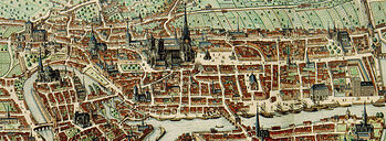
Illustration of La Cité north of the St. Crimse River during the 12th Century.
Increasing crime rates and a need for better urban planning resulted in the construction of the first official district of Rossterre: La Cité, by James I in the early 11th century. Over the next century, Rossterre continued to grow significantly, expanding further north and south across the St. Crimse River. A major port was constructed in Soude Envalides which prompted further population growth.
In the late 13th century, Thomas II began a major civil project to attempt to beautify and enhance the central district of Rossterre, ordering the paving of major thoroughfares, erection of the Place d'Atlas (in the centre of what is now the Rossterrian DCÉ), and extension of the Cathedral College of Este-Centrille into the first University in Helvore, the University of Rossterre, which still exists to this day.

Photograph of the Cathédrale de St. Petere, built in the 16th century.
In the following centuries Rossterre would experience progressive growth and expansion. By the early 16th century Envalides was merged into Rossterre in a larger urban chain. During the Reformation, Rossterre quickly became a major Soliterist stronghold. The Cathédrale de St. Petere was began by Maximilian III in 1547, which to this day remains one of the most important Soliterist churches in the world.
Rossterre entered a period of great volatility leading up to and during the Helvoran Revolution. In October, 1666, Vertrailles was stormed and Thomas VI executed. Many of the previously existing royalist statues, residences, and artworks were destroyed, and much of the Royal Palace was burnt down. During the Helvoran Civil War in the following decade, the city was in a perpetual state of conflict, with certain districts becoming aligned to Bayerist, Royalist, and Republican factions. After the Second Storming of Vertrailles, the monarchy was restored, and restorations of various buildings within Rossterre were commenced.
18th and 19th Century[]

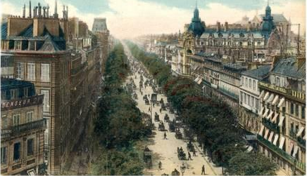
Illustration of the Avenue Richarde V in Bellétraite, one of Rossterre's most affluent districts. Bellétraite became a go-to destination for the rich and famous of Rossterre during the Helvoran Belle Époque of the 19th century.
In the years following the Helvoran Civil War the population of Rossterre once again grew, being almost 650,000 by 1750. Efforts to modernise parts of the inner city were begun by Richarde V shortly after coming to power, with the construction of the city's first sewer system, running water to most buildings in Vertrailles, and the repaving of the city's major roadways. Improvements to standards of living led to rapid population increase at the start of the 18th century.
In 1722, King Henri IV appointed the French architect Jean-Paul Sacré to begin an architectural restoration of Rossterre. Sacré began the reconstruction of the new Royal Palace of Rossterre, as well as the broadening of the city's major roadways into tree-lined avenues. His modernisation of the city led to a growing number of wealthy citizens settling in the new suburbs south of Vertrailles, in what is modern day Bellétraite and La Residentes.
The late 18th century saw the establishment of the Second Helvoran Empire and Helvore's victories over France in the Second Franco-Helvoran War. Monuments to the recent victories of King James IV were built, including La Toure and the Arche de Triomphe.


Photograph of one of the many interior halls of the National Museum of Helvore, the largest in the world.
Under the control of Napoleon Bonaparte during the Decade of Darkness, the iconic French Palace was constructed in the Place Napoléon. Following his eviction in 1815, Rossterre, along with the rest of Helvore, entered the Helvoran Belle Époque. Architecture flourished, and the city's increased wealth from the booming mining industry allowed for the construction of several of the city's most famous monuments.
Following the expansion of the colonial Franco-Helvoran Empire in the 19th century, Emperor Jules II commissioned the construction of the National Museum of Helvore to house the country's growing collection of exotic artefacts. Since then, the Naitonal Museum has grown to become the largest in the world.
20th and 21st Century[]

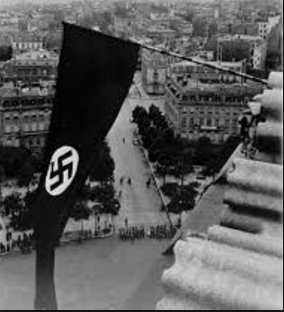
The Nazi Flag flies over occupied Rossterre, 1942.
By 1901, the population of Rossterre had grown to 1,000,000. The beautification of Rossterre's streets and it's emphasis on the Arts attracted many of the era's most famous artists, architects, and writers to live in Rossterre, including Marcel Proust, Georges Braque, Eric Ravel, Henri Rousseau, and Max Ernst. Internationally, Rossterre become renown for its Bohemian culture, exploration of 'new art', and as a home for philosophy and political radicalism.
During the First World War, Rossterre was bombed twice by German Zeppelins, remaining largely behind the front line. Following the wars, Rossterre continued to expand its artistic scene, with further artists, writers, and musicians making their home there.
In 1941, Rossterre was occupied by the Nazis as part of the annexation of Helvore. During the occupation of Rossterre, some 8,763 Jews and other non-Aryans were forcibly taken from their homes and sent to the Le Vel Concentration Camp outside Rossterre, never to return. Rossterre was liberated on the 28th of October, 1943 by the joint Helvoran and English Resistance and Armies under the leadership of General Nicholas Sentin and Queen Victoix III.


Aftermath of the July Terror Attack in Rossterre, the first to occur in the city.
Since the end of the Second World War, Helvore has continued to develop its infrastructure and art scene. Immigration rates have increased since the war, with the Helvoran population now being slightly over 1.2 million. Rossterre is still internationally renown as a centre for the arts, with many 20th and 21st century artists and writers calling the city their home.
On the 5th of July, 2017, Rossterre experienced its first major terror incident as three Muslim extremists bombed a train leaving Muséë Nationale. 21 people were killed, with a further 110 being injured as a result of the attack.
Geography[]
Main Article: Topography of Tosque
Rossterre is located on the Bay of St. Crimse on the central eastern coast of Helvore. By road, Rossterre is roughly 1,033 kilometres from Paris and London, with Du Montaine (the closest city to Rossterre) only 73 kilometres west. The St. Crimse River, which has its source near Monte Asencion, empties into the bay, with Rossterre being broadly spread across both its north and south bank.

Photograph of the suburb of Aivilaides-enne-l'Ere on the south coast of Rossterre.
Topographically, Rossterre is not flat, with several significant hills on the outskirts of both the north and south bank. The city's altitude steadily increases as one moves further north, with Rossterre's highest points - Monte Tosque and Monte Vertrailles - standing some 310 meters above sea level at the northernmost extremities of the city. The coastline also dips sharply at the river, meaning that there are cliffs along either side of the bay.
The south bank of Rossterre is generally flatter, with its highest point being Place Perséus in Esterecharde at 125 metres above sea level. The south bank is also home to the city's primary beaches, some of the best in Helvore, which are popular tourist attractions in Summer.
Climate[]
Rossterre has a fairly typical western European Oceanic Climate (Köppen climate classification: Cfb), being chiefly affected by the North Atlantic current and the Aquitanian Current. The overall yearly climate is fairly mild, although Rossterre is usually slightly wetter than other Helvoran cities.
Winters are generally quite cold due to the winds from the Atlantic coming over the Great Helvoran Mountain Range. Summers tend to be long and quite warm due to the influence of the Aquitanian Sea, with the average temperature being 25 degrees Celsius. Snowfall is common in the winter, although does not usually fall very heavily.
Cityscape[]
Suburbs and Arrondisementes[]

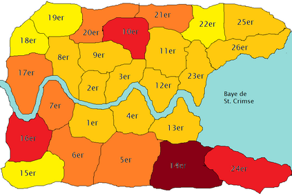
Map of the Arrondisementes of Rossterre, coloured by population density.
The City of Rossterre is divided into twenty-six Municipal Arrondisementes, administrative divisions which include a number of suburbs. Each Arrondisement has its own municipal government which is elected by its residents, with each government responsible for the upkeep of public services, building commission, and facility upkeep. The Arrond
isements are numbered in order, starting in Roixterre-Centrille (Arrondisemente 1er) and spiralling outwards clockwise. The last two digits of each suburb also refers to the Arrondisement that suburb is part of, for example, Noir Vertrailles, being in the 26th Arrondisemente, has the postcode 000-226. The list of Arrondisementes is as follows:
| Arrondisemente
('N' for North Bank, 'S' for South Bank) |
Name | Area (in km squared) | Population (2016) | Density of Population |
|---|---|---|---|---|
| 1er Arrondisemente - S | Roixterre-Centrille | 103 | 15,827 | |
| 2er Arrondisemente - N | St. Crimse | 84 | 17,432 | |
| 3er Arrondisemente - N | Seterre | 85 | 18,533 | |
| 4er Arrondisemente - S | Centrille-Parliamentes | 96 | 16,832 | |
| 5er Arrondisemente - S | Routlege | 142 | 73,482 | |
| 6er Arrondisemente - S | Tybalte-Vitrieres | 115 | 72,943 | |
| 7er Arrondisemente - S | Belgaide | 96 | 65,392 | |
| 8er Arrondisemente - N | Renne | 100 | 35,826 | |
| 9er Arrondisemente - N | Les Spires | 105 | 39,846 | |
| 10er Arrondisemente - N | Vendeume | 112 | 85,738 | |
| 11er Arrondisemente - N | Crébourge-Ancie | 99 | 47,463 | |
| 12er Arrondisemente - N | St. Léon | 84 | 42,736 | |
| 13er Arrondisemente - S | Envalides | 98 | 37,241 | |
| 14er Arrondisemente - S | Esterecharde | 138 | 146,392 | |
| 15er Arrondisemente - S | Alsaice-Bergendie | 92 | 14,732 | |
| 16er Arrondisemente - S | Roucharde | 106 | 91,020 | |
| 17er Arrondisemente - N | Bourbon | 117 | 79,406 | |
| 18er Arrondisemente - N | Velliers | 86 | 13,604 | |
| 19er Arrondisemente - N | Bourdeux | 95 | 12,114 | |
| 20er Arrondisemente - N | St. Richarde de Tosque | 96 | 65,402 | |
| 21er Arrondisemente - N | Noir Roixterre | 90 | 62,041 | |
| 22er Arrondisemente - N | Chapelle | 88 | 11,209 | |
| 23er Arrondisemente - N | Bellétraite | 96 | 52,348 | |
| 24er Arrondisemente - S | Aivilades | 121 | 92,412 | |
| 25er Arrondisemente - N | Monte St. Richarde | 97 | 57,312 | |
| 26er Arrondisemente - N | Vertrailles | 119 | 62,412 |
Landmarks and Architecture[]
Demographics[]
Ethnicity[]
Religion[]
Economy[]
Employment[]
Culture[]
Art[]
Museums[]
Theatre and Cinema[]
Literature[]
Music[]
Restaurants and Cuisine[]
Holidays and Festivals[]
Education[]
Universities[]
Libraries[]
Infrastructure[]
Transport[]
Railway[]
Air[]
Metrépolitaines[]
Waterways[]
Electricity, Water, and Sanitation[]
Parks and Gardens[]
Cemeteries[]
Media[]
Sister Cities[]
See Also[]
| |||||||||||||||||||||||||||||||||||||||||